

SITE LOGIN
- REVIEWS
- NEWS
- STORE
- ROUTES
- LODGING
-
VIDEOS
- 2022/23 Gear Reviews
- 2021/22 Gear Reviews
- 2020/21 Gear Reviews
- 2019/20 Gear Reviews
- 2018/19 Gear Reviews
- 2017/18 Gear Reviews
- 2016/17 Gear Reviews
- 2015/16 Gear Reviews
- 2014/15 Gear Reviews
- 2013/14 Gear Reviews
- 2012/13 Gear Reviews
- 2011/12 Gear Reviews
- 2020 Outdoor Retailer
- 2019 Outdoor Retailer
- 2018 Outdoor Retailer
- 2017 Outdoor Presscamp
- 2017 Outdoor Retailer
- 2016 Outdoor Presscamp
- 2016 Outdoor Retailer
- 2015 SIA Show
- 2014 Outdoor Retailer
- 2013 SIA Show
- 2012 Outdoor Retailer
- Tips and Tricks
- Backcountry Skiing
- SAFETY
- ABOUT
- Home
- »
- ROUTES
- »
- Rocky Mountains
- »
- Waterton
WATERTON
All the locations contained within this book are located on the traditional lands of The Tsuu T’ina, The Michif Piyii (Métis), The Ktunaxa amak?is, The Niitsitpiis-stahkoii (Blackfoot), The Očhéthi Šakówin and likely many others. This geographic region is significant to many Indigenous Nations of Turtle Island because of its easy access to the interior mountain ranges and also to the great plains. It is a valuable trade route still to this day for a huge part of the planet. The many traditional peoples of this region still inhabit and care for these lands. We can access the region today because they have cared for these lands since time immemorial and continue to protect them for generations to come. If you are lucky enough to visit this spectacular part of this planet, you are responsible to leave the lands the way you found them and pay respect to the rightful owners of the land. Please take time out of every day to recognize where you are standing, the people who came before you, who you are and who will come after you.
The areas and routes described below are designed to be enjoyed by all skiers, split borders and telemark skiers. Some areas described have a wide variety of terrain, some of which contain dangerous avalanche terrain that should be entered with extreme caution and some are very benign. The route times vary slightly because they depend greatly on your speed. I recommend you spend a day at each place and think about how you can link up some of the tours into larger trips. Most of the places warrant doing a couple of laps so book a night in the hut, bring your tent and camp in Akamina pass or stay the night in Waterton at the very well-appointed and reasonably priced hotels.
The Geography of the Region is characterized by long ridges that extend great distances with rounded tops. Some jagged peaks exist with some large cliff faces but they are rare and most of them are concentrated near the divide to the North closer to the Crowsnest Pass.
The riding season in the Cameron Lake Region starts in early December and goes all the way to April. People can be found riding in November and as late as May but a bike to gain access may be required and will help you easily extend your season and provide a fun multisport experience! The wind has eroded and swept nearly every corner of the area. Trees sometimes find it hard to grow in the wind almost as if they were in an avalanche path constantly being abraded and maligned by the wind day after day after year.
The ridges provide great opportunities for riding on their lee side (imagine they are massive snow fences). They provide massive lee areas where weather can be calm and undisturbed while only 20m away the wind howls in the fetch, saltating snow nearly constantly to the lees. Train car size cornices grow easily at ridge tops, wind slabs are nearly omnipresent in the region and hard slabs are an annual occurrence during windy dry spells.
A note about avalanche conditions in the burnt forest is necessary; suffice to say that if in doubt you should treat all terrain as if it were “Alpine” not “Tree Line'' or “Below Tree Line''. Surface hoar (SH) can grow very quickly and widespread because all of the terrain is open to the night sky. The winds often flatten and disturb much of the SH but it can be lurking in lee areas and especially at lower elevations as well as in the lees below ridgetop. Warm Chinook winds race through the region often providing rising freezing levels and massive amounts of moving snow. Snowfall amounts are significantly higher West of and along the great divide. Upslope storms are also common in the region where winds from the East push moisture and warmer air towards the mountains forcing it to snow by orographically lifting the moist air with the advancing front. These are often associated with a “colorado low” south of the border. These upslope events can bring significantly more snow to the front ranges and reverse loading often occurs. A Zonal westerly flow can bring large amounts of precipitation but it will often remain close to the great divide.
Camping, Huts and Accommodations
The Alpine Club of Canada, Cameron Lake Cabin is located along the Cameron Lake road only 3 Km from the Little Prairie day-use area. Bookings can be made through the club at www.alpineclubofcanada.ca There is also a backcountry campsite in the Akamina-Kishinena Provincial Park 4.5 Km from the Little Prairie day-use area. There is a pit toilet and food bins, please practice “leave no trace” camping ethics and pack out what you pack in. Several Hotels such as the Glacier Inn, The Waterton Lake Lodge and Crandell Lake Inn are open year-round in the townsite of Waterton. Accommodations can also be found in the city of Pincher Creek in several large hotels and many more great bed and breakfast accommodations exist as well in the area. There are still more accommodations in Beaver Mines and at Castle Mountain Resort.
CAMERON LAKE AREA ROUTES:
1. Rowe South East Side
2. Rowe South West Shoulder
3. Rowe Bowl
4. Wall Ridge
5. Biscuitboard Drainage
6. Forum Ridge
7. Summit Lake
8. Little Prairie Parking lot Paths
We want to hear about your adventures in Waterton so don’t forget to post a trip report in the backcountryskiingcanada.com forums. For a full listing of backcountry huts, cabins and lodges check out the Coast Mountain cabins/huts/lodges page over here. If you have a new route in the area you want to share, mouse-on over here. N-Joy.
All routes listed here are graciously provided by Chris Girard who is an ACMG Ski Guide based out of Cochrane, Alberta. He hopes that you enjoy the routes he's provided and consider donating to the preservation of the Yellowstone to Yukon corridor. If we have missed anything please let us know?
Backcountry skiing is an inherently dangerous activity that requires experience and knowledge to travel safely. Any of the routes on this site may be dangerous depending on conditions. You are responsible for your own safety in the backcounty—the team behind backcountryskiingcanada.com disclaim any responsibility for any injury resulting from people traveling on routes described on this site. To read our Terms of Use and get all the details, read HERE.
This zone is very easily reached from the little prairie parking lot by heading south (approx ½km) on the road toward Cameron Lake, climbing the burnt forest on the West side of the road using the gentle ribs that rise away from the road. Several narrow avalanche paths like fingers
face East on this aspect of Mt Rowe. Wind slabs often lurk at the ridgetop making the descent from the summit very dangerous and extremely rare. There are several ribs where safe riding can be had below 2100m at grid point 11 U 715300 5436044 nicely spaced trees can be found
all the way back to the car. This trip is great if you want a half-day or simply want to be able to slide back to the car without skinning up from some other runs farther back in the AK park.
Photo taken from Forum Ridge looking North across Akamina Pass.
 ROUTE: #1
ACCESS: Little prairie parking lot by heading south (approx ½km) on the road toward Cameron Lake.
MAP: 82 G/1 Sage Creek
TIME: 3-4hrs
ELEVATION GAIN: 400m/1312'
ATES RATING: Challenging (2)
submitted by: Chris Girard
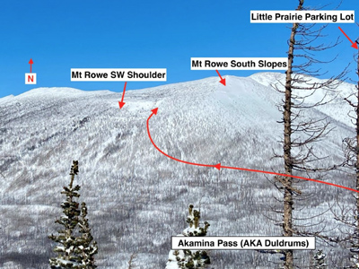
Leave the Little Prairie day-use area and head south for 500m then start contouring gradually to the Southwest until you round the corner at 11U 715472 5435523 then head easily West and find your way around a few small cliff bands from time to time. This entire SW shoulder of Mt Rowe is prone to cross-loading because of its orientation to the Akamina Pass which very often can concentrate and funnel winds. The ridge is very broad so you have lots of space to make fresh turns. There is a large alpine bowl at the far West end of the ridge which can have some fantastic riding depending on recent wind direction. If you ride to the basement it is worthwhile to skin back up and contour back around to the East at 1950m in order to be able to slide easily back to the parking lot. The key is to avoid “The doldrums'' of the Akamina Pass. It is a very wide flat and sometimes undulating pass where time is easily wasted.
Photo taken from Forum Ridge looking North across Akamina Pass.
 ROUTE: #2
ACCESS: Little prairie parking lot by heading south (approx ½km) on the road toward Cameron Lake.
MAP: 82 G/1 Sage Creek
TIME: 4-5hrs
DISTANCE: 11km/6.8miles
ELEVATION GAIN: 350m/1,148'
ATES RATING: Challenging (2)
submitted by: Chris Girard
From the little prairie parking lot ski south 300m along the Cameron Lake Road until you cross over the runout of the Rowe bowl and ascend the south side of the path until you gain the bowl proper around 1880m then cross the bowl and ascend the treed slope in the centre of the bowl to the ridgetop. The bowl is prone to avalanche and you are exposed in a dangerous terrain trap where you are exposed to multiple avalanche hazards. You can choose several descents of varying steepness but they all go through the terrain trap at the bottom of the bowl so extra caution should be taken. This was the site of a tragic fatality and extreme caution should be taken on this route.
No photo for this one but it is very easily visible from the road from the Little Prairie parking lot to Cameron Lake.
ROUTE: #3
ACCESS: Little prairie parking lot by heading south (approx 330m) on the road toward Cameron Lake.
MAP: 82 G/1 Sage Creek
TIME: 2-3hrs
DISTANCE: 5km/3.1miles
ELEVATION GAIN: 630m/2,067'
ATES RATING: Complex (3)
submitted by: Chris Girad
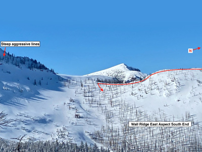
Ski South from the Little Prairie parking lot then follow the Akamina pass trail to the BC border. Continue on the Akamina Pass Descending into BC for a few hundred metres. Turn left and take the Forum lake trail up past the warden's cabin and ascend the gentle treed North Facing slope heading West towards Wall ridge. Nice turns can be had in many places along the ridge but there are several cliffs on the East side of the ridge only apparent early season and extra caution should be taken around these shallow snowpack areas. The most protected turns can be had at the southernmost end of the ridge where it meets Akamina Ridge proper. You can easily ascend the North end of the ridge and traverse its entirety before riding the protected slope on the South end. Extra caution should be taken here as the cornices can be quite large and unpredictable.
These photos are taken from Forum ridge looking West, the Insert photo was taken from Rowe Shoulder looking South.
 ROUTE: #4
ACCESS: Ski South from the Little Prairie parking lot then follow the Akamina pass trail to the BC border.
MAP: 82 G/1 Sage Creek
TIME: 4-5hrs
DISTANCE: 12km/7.5miles
ELEVATION GAIN: 520m/ 1,706'
ATES RATING: Challenging (2)
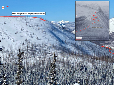
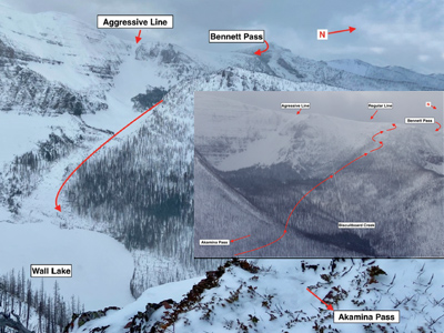
You can do this trip with two variations. You can ski directly to Biscuitboard creek following the Akamina Pass trail until you meet the Wall lake Trailhead at the Akamina Campground. Follow the Wall lake trail until it turns sharply south around UTM 713115 5434614 where you continue North West past Wall Creek and contour North West along a subtle draw and bench from UTM 712700 5434292 until you reach Biscuitboard creek and drainage. Ascend the NorthWest side of the creek using the lowest angle terrain to reach a beautiful larch forest which somehow evaded the fires. This larch forest is a good way to avoid the avalanche path which threatens a great deal of the head of the drainage and provides a great 300m run. There is often a cornice atop the ridge that is passable on the Northwest end of the ridge. There is a route you can descend and make this tour a beautiful circuit that passes to the Southeast through a small hanging valley above Wall lake. This circuit will require very good stability as there is a large unsupported start zone and avalanche path that threatens this hanging valley to Wall Lake. Evidence of large avalanche events are found on the North edge of the Lake where a large avalanche broke a hectare of trees originating high above the lake on Akamina Ridge.
Photo taken from Wall Ridge looking West Toward Bennett Pass. Insert taken looking South from Rowe Shoulder toward Biscuitboard and Bennett Pass.
 ROUTE: #5
ACCESS: Follow the Akamina Pass trail until you meet the Wall lake Trailhead at the Akamina Campground.
MAP: 82 G/1 Sage Creek
TIME: 5-6hrs
DISTANCE: 16km/9.9miles
ELEVATION GAIN: 440m/1,443'
ATES RATING: Challenging (2)
submitted by: Chris Girard
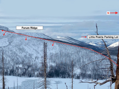
Without a doubt, this is the best and most well-known riding destination in the area. It is easily accessed from skiing south from the Little Prairie Parking lot towards Cameron Lake. Once passed the Southernmost unnamed creek running East from Akamina Pass, gain the ridge passed UTM 715732 5433907. The creek banks further upstream are needlessly dangerous to navigate and are easily avoidable if crossed at lower elevations. Once on top of the ridge continue South as far as you like knowing that the Avalanche terrain is more committing the farther South you go. There are some large openings in the trees that are visible in the adjoining photo so pick your lines carefully depending on the conditions. Ride East to Cameron Lake and repeat until your legs feel like jello. Riding West from Forum ridge is possible but the trees are still alive and can be quite tight until later in the season, not to mention the run is quite a bit shorter. The west side of the ridge is most often facing the wind and the quality of riding can be less than enjoyable.
Photo taken from Summit lake area with Cameron Lake below and looking at Forum ridge's East aspect.
 ROUTE: #6
ACCESS: Little Prairie Parking lot head towards Cameron Lake.
MAP: 82 G/1 Sage Creek
TIME: 2-3hrs
DISTANCE: 12km/7.5miles
ELEVATION GAIN: 510m/1,673'
ATES RATING: Challenging (2)
submitted by: Chris Girard
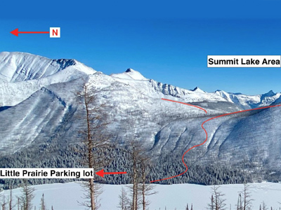
This zone provides a lot of great aspects that are protected depending on the latest storm. From the Little Prairie Parking lot head to Cameron lake. The easiest route to summit lake is to gently switch back towards UTM 716800 5432909 on a broad rib feature. The main feature to avoid on the uptrack is a subtle gully and cliff hiding just north of this point which is large enough to ruin your easy up track. When the terrain flattens you can head South wrapping around the Eastern Flank of a small summit to the West of Summit lake. You can descend all sides of the small summit depending on conditions. The longer lines to the south “the border lines” must be taken with caution as they are steep and committing as well as the lines west down to Cameron Lake. Very safe riding can be found descending towards Summit lake where you can skin up and do some more turns on the South side of Buchanan Ridge. If you are looking to make a nice loop and a longer day you can descend the committing slopes to the south and come back across the ridge through a pass dividing Mt. Custer from the Summit lake area.
It should be noted that depending on the routes you take South you will be crossing into the USA and arrangements should be made with the proper border authorities in order to not be entering either country illegally.
Photo of Summit Lake West Aspect taken from Forum Ridge Cameron Lake below.
 ROUTE: #7
ACCESS: From the Little Prairie Parking lot head to Cameron lake.
MAP: 82 G/1 Sage Creek
TIME: 4 hours
DISTANCE: 12km/7.5miles
ELEVATION GAIN: 410m/1,345'
ATES RATING: Challenging (2)
submitted by: Chris Girard
LITTLE PRAIRIE PARKING LOT PATHS
Directly NW of the Little Prairie Parking lot there are a few avalanche paths that come from the North East Ridge of Mt Rowe. The cliffs above the paths can become full of snow and avalanche onto the low-angle terrain below. These runs are open and low angle making them ideal for beginners. The risk of avalanche is quite low here but present nonetheless so all the regular precautions must be taken. While the snowpack is shallow (below 1m) extra caution must be taken because there are many stumps and hazards that exist. The runs are very short giving people the opportunity to practice skinning, turning and transitioning before heading out on longer trips.
No Photo of this trip yet but it is very visible from the parking lot.
ROUTE: #8
ACCESS: Directly NW of the Little Prairie Parking.
MAP: 82 G/1 Sage Creek
TIME: 1hr
DISTANCE: 1.5km/0.9miles
ELEVATION GAIN: 150m/492'
ATES RATING: Challenging (2)
submitted by: Chris Girard
Copyright © 2009-26 Backcountry Skiing Canada. All Rights Reserved.
