Logo
Tailgate Industries
Show
Hide
Login
Close

SITE LOGIN

  • Forgot your password?

Register

  • REVIEWS
    • Ski Gear
      • Skis
      • Boots
      • Bindings
      • Climbing Skins
      • Poles
      • Snowboards
    • Clothing
      • Hard Shells
      • Soft Shells
      • Insulation
      • Mid Layers
      • Base Layers
      • Gloves
      • Socks
      • The Best Backcountry Hats
    • Accessories
      • Safety Gear
      • Goggles and Helmets
      • Ski Touring Packs
      • Ski Boxes and Bags
      • Sleeping Bags - 4 Season
      • Technology
      • Sunglasses
      • Insoles & Braces
      • Books
    • Summer Gear
      • Summer How-to
        • What to Wear Hiking
        • Guide to Hiking Trail Ratings
      • Hiking
        • Rain Shells
        • Day Packs
        • Apparel
        • Footwear
          • Best Hiking and Trail Running Shoes
        • Safety
        • Footwear
      • Camping
        • Backpacks
        • Sleeping Bags
        • Sleeping Pads
        • Tents
        • Coolers / Cooking
        • Furniture / Storage
        • Lighting / Power
      • Biking
      • Paddling
      • Climbing
      • Mountaineering
      • Running
    • Lifestyle
    • Lodges and Accommodation
    • Nutrition
    • Manufacturers
    • Destinations
    • Training
    • Gear of the Year
      • Gear of the Year Winter 2024-2025
      • Gear of the Year Winter 2023-2024
      • Gear of the Year Archives
    • Best New Summer Gear
      • Best New Summer Gear 2025
      • Best New Summer Gear 2024
      • Best New Summer Gear 2023
      • Best New Summer Gear 2022
      • Best New Summer Gear 2021
      • Best New Summer Gear 2020
    • Holiday Gift Guide
    • Pro Skier Interviews
  • NEWS
    • Gear Talk
    • Safety Talk
    • Touring Locations
    • Backcountry Hikes
    • Pro Services
    • General
  • STORE
    • Guides & Maps
    • Buy Guides and Maps Locations
    • Gear Deals
      • Alpine Touring Boots
      • Backcountry Skis
      • Alpine Touring Bindings
      • Backcountry Accessories
      • Off-Season Gear
      • Climbing Skins
  • ROUTES
  • LODGING
    • Coast Mountains
    • Interior Mountains
    • Rocky Mountains
  • VIDEOS
    • 2022/23 Gear Reviews
    • 2021/22 Gear Reviews
    • 2020/21 Gear Reviews
    • 2019/20 Gear Reviews
    • 2018/19 Gear Reviews
    • 2017/18 Gear Reviews
    • 2016/17 Gear Reviews
    • 2015/16 Gear Reviews
    • 2014/15 Gear Reviews
    • 2013/14 Gear Reviews
    • 2012/13 Gear Reviews
    • 2011/12 Gear Reviews
    • 2020 Outdoor Retailer
    • 2019 Outdoor Retailer
    • 2018 Outdoor Retailer
    • 2017 Outdoor Presscamp
    • 2017 Outdoor Retailer
    • 2016 Outdoor Presscamp
    • 2016 Outdoor Retailer
    • 2015 SIA Show
    • 2014 Outdoor Retailer
    • 2013 SIA Show
    • 2012 Outdoor Retailer
    • Tips and Tricks
    • Backcountry Skiing
  • SAFETY
    • Plan Ahead
    • Equipment
    • Resources
    • Avalanche Skills Training
    • Managing warmth & heat loss
  • ABOUT
    • Advertise
    • Glossary
    • Contact Us
    • Newsletter
    • Contest
    • Affiliate Disclosure
    • Contributor Guidelines
  • REVIEWS
    • Ski Gear
    • Clothing
    • Accessories
    • Summer Gear
    • Lifestyle
    • Lodges and Accommodation
    • Nutrition
    • Manufacturers
    • Destinations
    • Training
    • Gear of the Year
    • Best New Summer Gear
    • Holiday Gift Guide
    • Pro Skier Interviews
  • NEWS
    • Gear Talk
    • Safety Talk
    • Touring Locations
    • Backcountry Hikes
    • Pro Services
    • General
  • STORE
    • Guides & Maps
    • Buy Guides and Maps Locations
    • Gear Deals
  • ROUTES
  • LODGING
    • Coast Mountains
    • Interior Mountains
    • Rocky Mountains
  • VIDEOS
    • 2022/23 Gear Reviews
    • 2021/22 Gear Reviews
    • 2020/21 Gear Reviews
    • 2019/20 Gear Reviews
    • 2018/19 Gear Reviews
    • 2017/18 Gear Reviews
    • 2016/17 Gear Reviews
    • 2015/16 Gear Reviews
    • 2014/15 Gear Reviews
    • 2013/14 Gear Reviews
    • 2012/13 Gear Reviews
    • 2011/12 Gear Reviews
    • 2020 Outdoor Retailer
    • 2019 Outdoor Retailer
    • 2018 Outdoor Retailer
    • 2017 Outdoor Presscamp
    • 2017 Outdoor Retailer
    • 2016 Outdoor Presscamp
    • 2016 Outdoor Retailer
    • 2015 SIA Show
    • 2014 Outdoor Retailer
    • 2013 SIA Show
    • 2012 Outdoor Retailer
    • Tips and Tricks
    • Backcountry Skiing
  • SAFETY
    • Plan Ahead
    • Equipment
    • Resources
    • Avalanche Skills Training
    • Managing warmth & heat loss
  • ABOUT
    • Advertise
    • Glossary
    • Contact Us
    • Newsletter
    • Contest
    • Affiliate Disclosure
    • Contributor Guidelines
Newsletter Signup

TOP VIDEOS

    HOTTEST REVIEWS


    Hagan Boost 99 POW Skis Garmin inReach Plus Scarpa 4-Quattro Pro 130+ Top Ski Reviews Ortovox Ravine Jacket Scarpa Maestrale RS Boots

    Ortovox
    Fritschi Swiss Bindings
    ROAM
    Marker Kingpin
    Avalance Canada
    Search
    • Home
    • »
    • Forum
    • »
    • General Talk
    • »
    • General Talk
    • »
    • Fall Hiking Hit List: The Rock Wall Trail

    BACKCOUNTRY NEWS AND FORUMS

    Welcome to your source for the latest news, conditions, and insights on backcountry skiing and adventuring. Explore reports, gear reviews, safety tips, and more to help you make the most of your time in the wild.

    If you sign up as a member this is your chance to tell everyone about everything and anything to do with backcountry skiing. Follow the simple steps to register and WHAMMY, you’re in. If you are pulling your hair out with frustration, have a look at the help forums for answers or take a pause and drop us an email at: info (at) backcountryskiingcanada.com. We’ll do our best to help out as soon as we can (but all bets are off on a powder day, obviously).  


    Fall Hiking Hit List: The Rock Wall Trail

    • RSS
    • Subscribe
    • admin
      2017-09-29 09:26:39

      Fall Hiking Hit List: The Rock Wall Trail

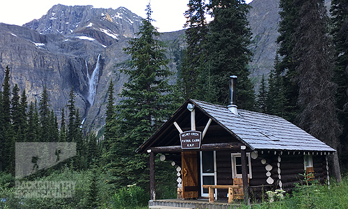
      At 55.6 kilometers in length, the Rockwall Trail located in Kootenay National Park is one of Canada’s best, not because of its location or length but because hikers will spend 3-4 days passing below towering limestone cliffs that can reach almost 3,000 feet from their base. On trail, you won’t get tired of the stunning scenery, the wildflower meadows or larch forests, and as if that wasn’t enough, the Rockwall Trail will take you past Helmet Falls – one of the highest waterfalls in the Canadian Rockies at 352m / 1,154 feet. 

      The Rock Wall Trail

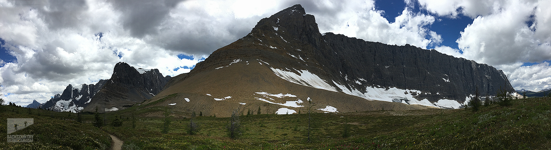
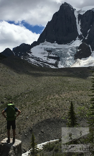
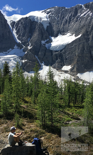
      The Rock Wall is a truly unique geological feature, a massive limestone escarpment in Kootenay’s Vermilion Range. It’s covered with glaciers and towers some 900m / 3,000 feet above the trail below, along the hike you’ll have the Rock Wall at your side for more than 30km / 18miles. The trial itself is easy to follow and well marked rising from 4,300ft to a maximum height of around 7,700ft in elevation.

      The Rock Wall Trail

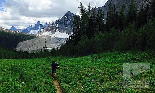
      On day one we left the Floe Lake trailhead at highway 93 and hiked up to Flow Lake where we ate lunch and continue onto our reserved campsite at Numa Creek. This first day is always the hardest as it requires the most elevation gain and takes you to the highest point on the hike, this all has to be taken on with a fully loaded pack which contains three days worth of food. Starting in a sparse forest you quickly gain elevation and get your first views of the rock wall with Floe Lake at its base. This is an ideal rest location, not only for the obvious beauty surrounding you but also because from here you still have substantial climbing to get up and over Numa Pass. The Pass is exposed and barren of shelter so be sure the weather coming in supports getting through the pass without stopping. After the pass, it’s all downhill as you wind your way to Numa Creek Campground. While this is the least appealing campground on the route to it’s a great objective for the first day with just over 20km under your boots.

      The Rock Wall Trail
      The Rock Wall Trail

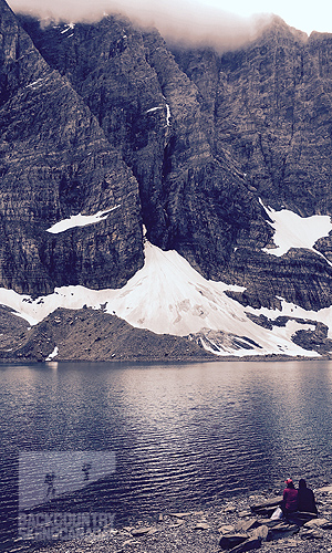
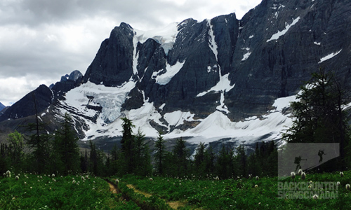
      Day two’s objective was Helmet Falls Campground a further twenty kilometers along the trail with a fair amount of climbing en route as well as a moderate amount of down. Over the course of the day, we’d pass by a glaciated lake, hike through beautiful tamarack forests and witness Wolverine Pass, which is the only break in the massive rock wall feature. The views on this day far surpass the first day’s vistas, partially due to the rock wall itself but mostly thanks to Helmet Falls which perfectly frames the campground in the distance. At over 352m / 1,154ft in height, Helmet Falls is one of the highest waterfalls in the Canadian Rockies and a stunning spectacle that bests any TV show out there. The campground itself is extensive and offers a dedicated cooking area in which to socialize and share stories with hikers from all over the world.

      The Rock Wall TrailThe Rock Wall Trail


      The final day of our hike would be mostly downhill with a loss of almost 700 meters. You are able to cover this distance fairly quickly as the walking is easy and rather mundane as the views are all behind you and pale in comparison to the previous two days. About 1 km from the parking lot at the trail terminus you’ll pass by the Painted Pots which are worth taking in and spending some time reading the interpretive signs. Once you reach the parking lot it’s time to flag down a ride back to the Floe Lake trailhead. This is no easy feat as the traffic moving quite fast and since most are tourists they tend not to stop. Don’t beat yourself up if it takes you 30min or more to convince some busy driver to take pity on a poor smelly hiker (or two).

      If you are considering hiking the Rock Wall Trail, do yourself a favour and hike north to south. Not only will you have gentler climb up to elevation but all the scenery will be in front of you as you hike. The traditional south to north direction means that all the views are all behind you and you end up missing a lot if you forget to turn around.

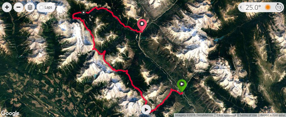
      View the route and all the trip stats here on our Garmin Connect page, I tracked the route with my Fenix3 GPS watch.

      The Rock Wall Trail

      Logistics:
      Permits: Backcountry camping/wilderness permits are required for each hiker each night they spend on the Rock Wall Trail. Permits cost $9.80/person/night and there is also a non-refundable reservation fee of $11.70. This trail is popular and campground space is limited so book early to avoid disappointment as Parks Canada limits the number of people at each campsite. Each person will also have to pay to enter Kootenay National Park. 

      Transportation: If you intend on hiking the entire Rock Wall Trail then both access points are located on Highway 93 South, which is the only major road running through Kootenay National Park. You’ll want to park at the Floe Lake Trailhead and once your hike is complete you’ll exit at Paint Pots Trailhead. If you didn’t drop a shuttle car then you’ll have to hitchhike back 14km  in order to retrieve your car.

      Hiking: Most people hike south to north but I would strongly recommend you do it in reverse so that the views are all before you rather than in the rearview mirror. Dogs are allowed on the trail, but they must be on a leash at all times. Bikes are not allowed on the trail and campfires are not permitted anywhere on the trail at any time.

      Recommended time of year to hike this trail: Mid-July to early October.

      Food: Bear-proof food storage lockers are provided at each campground. Use them.

      Essentials:
      First Aid Kit: Should include a blister kit, medications and a knife.
      Map: Know your route and trail conditions in advance and know where camps are located.
      Headlamp: Bring a proper flashlight or headlamp along with spare batteries as a cell phone does not provide enough light to hike with at night, which you may be forced to do.
      Gear: Layer clothes to protect yourself from the sun and cold weather which can and does change rapidly. Hiking poles also help lower impact and fatigue on your joints.
      Self-Rescue: Be self-sufficient, as rescue is never guaranteed immediately due to weather and resources.

      Itinerary:
      Day One: Floe Lake trailhead to Numa Creek Campground, 20.7km / 12.9miles, 6 hours
      Day Two: Numa Creek Campground to Helmet Falls Campground, 20.2km / 12.6miles, 6 hours
      Day Three: Helmet Falls Campground to Paint Pots Trailhead, 14.7km / 9.1miles, 4.5 hours

      Details:
      Distance: 55km / 34miles
      Hiking Time: 3-4 days
      Elevation Gain: 2,671m / 8,763ft
      Difficulty: Moderate
      The Rock Wall Trail


    Ortovox
    Fritschi Swiss Bindings
    ROAM
    Marker Kingpin
    Avalance Canada
    • Terms of Use
    • Privacy Policy

    Copyright © 2009-25 Backcountry Skiing Canada. All Rights Reserved.