




• Weekly avalanche conditions report
    Weekly Episode

    Avalanche Conditions Report

    Weekly snowpack summary covering Rogers Pass, the Selkirks and the Canadian Rockies. Published every Friday throughout the season.

    Listen Now →

    Weekly avalanche & safety updates throughout the season

  • BSC Guide Books
    Proprietary Content

    BSC Guide Books & Maps

    Researched and written by our team. Printed guides and georeferenced digital maps for Canada's best backcountry terrain.

    Shop the Store →

    Printed guides + georeferenced digital maps — all authored by BSC

  • BSC Membership

    Access 300+
    Full Routes

    Subscribe to Backcountry Skiing Canada and unlock complete route descriptions, trailhead details, approach beta, seasonal conditions and linked digital maps — for every route we've documented across Western Canada.

    • 300+ full route descriptions with trailheads, approach notes and descent options
    • Georeferenced digital maps — Gaia GPS and CalTopo compatible
    • ATES-rated and updated each season with current conditions beta
    • Support independent backcountry skiing content since 2009
    Subscribe to BSC Browse free content →

    Route details also available in BSC printed guidebooks

  • Know Before You Go

    Check Today's Forecast

    Real-time avalanche danger ratings updated daily by Avalanche Canada. Always check before heading out.

    View Forecast →

    Avalanche awareness saves lives

  • Know Before You Go

    Check Today's Forecast

    Real-time avalanche danger ratings updated daily by Avalanche Canada. Always check before heading out.

    View Forecast →

    240+ videos — gear reviews, conditions reports & backcountry edits

Viewranger Mobile Map App – REVIEW

  • Online
    2013-01-14 13:13:09

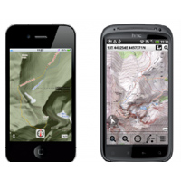
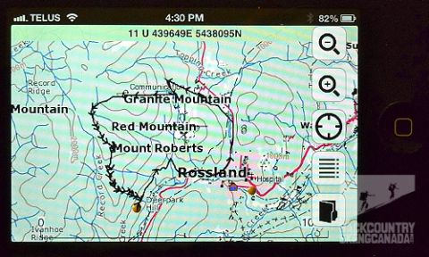
    View Ranger Mobile Map App Viewranger is an easy to use application that turns your smart phone into a fully functioning GPS, at least when you’re in cell range. With that obvious limitation, the true beauty of View Ranger isn’t the application itself – which could be improved for front/backcountry skiing (more on this later) – but rather the remarkable licensed database of topographic maps available for purchase.


    Viewranger not only uses open source web maps available on many similar mapping applications, but also detailed government-issue topographic maps that are available for purchase. Why is this a benefit? 


    Read the full review over here.


    If you would like your own FREE copy of the View Ranger Mobile Map App complete with Canadian Topographic Maps simply respond below and let us know why. We will be picking 10 lucky winners this week,… so get on it!

    Check back in a few days to see if you are a winner as we be posting the winners here.

    View Ranger Mobile Map App


  • 2013-01-14 20:18:39

    Very cool program.  I am probably not going to win a copy with my comments but will give my two cents worth anyway!


    There are other gps apps for smartphones that DO NOT need a cell phone signal, which is obviously a huge plus in the Kootenays where cell service is spotty at best.


    Call me "old school" but I prefer to carry a map, compass and garmin gecko gps.  These three things together weigh less than my iphone and I don't have to worry about my iphone battery dying in the cold (which it seems to do a lot).


    Just my opinion, interested to see what others have to say....

  • 2013-01-15 02:08:06

    JohnP said:

    There are other gps apps for smartphones that DO NOT need a cell phone signal, which is obviously a huge plus in the Kootenays where cell service is spotty at best.


    Which GPS apps have you used that you don't need a signal? I'm curious about this, ive yet to find an app that works well out of service

  • 2013-01-15 04:06:33

    John, I'm in the same boat as you. If I'm relying on maps in the backcountry then its paper and a compass, with my dedicated GPS as secondary backup. When mobiles can perform at the same levels as GPS's in the backcountry with limited or no coverage then I will consider changing. I will stick to purpose built/designed devices when my life is in the balance!
  • 2013-01-15 20:47:38

    In response to erathge above, I asked my friend (who uses his iphone in the BC):


    The app, which I use  is just an all purpose GPS app, and it is just called MotionX GPS.  It is the one that will chart a track, give you your coordinates, has a built in compass, etc.  As I mentioned, it doesn't need cell towers, and you can download maps ahead of time if you are going somewhere that won't have 3G access.  The GPS works off satellite, so doesn't need 3G.
    I did a quick google search and it appears there are lots of others too.
    Hope that helps,
    John


  • 2013-01-16 07:14:13

    I'm going to join the "great-in-theory" camp - I recall my AST instructor telling us that mobile phone radio frequencies can interfere with avalanche transcievers so your phone should be in flight-mode or in your backpack/30cms away from your transciever, possibly limiting the usefulness of such software for use in avalanche terrain. Sounds fantastic for hiking/biking though (kootenay cell coverage notwithstanding).

  • 2013-01-17 22:20:19

    Hmmm.. Interesting.  I wonder how well it will work in the Alberta Rockies with a bit better coverage.
  • 2013-01-18 11:17:28

    I think it is a neat app. Not something to be relied on of course, but it would be fun to have to be able to whip out your phone and chat with friends about routes and areas when you don't have maps around.
  • 2013-01-18 13:28:04

    I downloaded and took a quick look at this.  I don't know how useful it will be in backcountry but it seems to have a nice interface to the OSM maps which are very useful for local hikes around Victoria, better than some of the other OSM apps I've tried.  I will try using it with downloaded maps only this weekend.
  • 2013-01-18 19:18:54

    It would be neat to try this out. I hope it works in Kananaskis to maybe check to see what is over the next col! I've just got to keep an eye on the battery.
  • 2013-01-18 20:43:07

    Looks cool to me. I'd love to check it out. Sign me up, count me in. etc
  • Online
    2013-01-19 15:15:52

    Thanks for the insight all and if you are interested in a FREE copy of the View Ranger Canadian Topos send me an e-mail with your e-mail address and we will send you the details on how to download your prize. We have 10 copies to give away so the first 10 to respond to me at [email protected] WINS!


    If this is you then e-mail me asap:

    JohnP

    Erathge

    Red PeeKay

    Gingerbeardman

    Nohodads

    Mike

    mhofmannskis

    skiitsbetter

    Crystaline

  • 2013-01-19 19:47:29

    further to my post above, BCA just posted an article about an ISSW paper on transciever interference from electrical devices including radios, mobile phones, gps devices and cameras

    http://www.backcountryaccess.c.....erference/