

Backcountry Skiing Duffy Lake map
A topographic route map for backcountry skiing in the Duffey Lake area of Southwestern BC by John Baldwin.
|
|
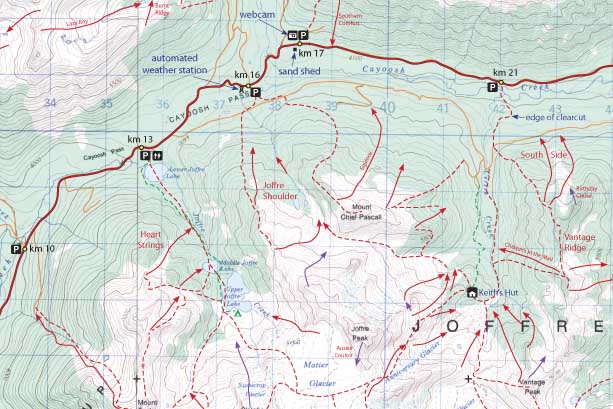
Duffey Lake describes backcountry skiing and hiking routes to alpine areas accessible from the Duffey Lake area surrounding Cayoosh Pass along Highway 99 in southwestern British Columbia. Routes are marked on a 1:50,000 scale topographic map and include information on ski ascent routes, ski runs, backcountry cabins, popular names, hiking trails, driving distances and parking areas.
Features:
- customized topographic map
- detailed ski routes
- backcountry ski runs
- hiking trails
- waterproof, tearproof
- table of slope angle relative to contour spacing
- 1 km UTM grid lines
- latitude and longitude
- three-dimensional shaded relief
- metric conversion table
- scale 1:50,000
- contour interval 100ft
- 24" X 36"
- folds to 4.25" X 9"
- waterproof and tearproof
- full colour
Duffey Lake is a customized topographic map based on the Canadian NTS Topographic maps 92J/7 and 92J/8.
PRICE: $25.00