




• Weekly avalanche conditions report
    Weekly Episode

    Avalanche Conditions Report

    Weekly snowpack summary covering Rogers Pass, the Selkirks and the Canadian Rockies. Published every Friday throughout the season.

    Listen Now →

    Weekly avalanche & safety updates throughout the season

  • BSC Guide Books
    Proprietary Content

    BSC Guide Books & Maps

    Researched and written by our team. Printed guides and georeferenced digital maps for Canada's best backcountry terrain.

    Shop the Store →

    Printed guides + georeferenced digital maps — all authored by BSC

  • BSC Membership

    Access 300+
    Full Routes

    Subscribe to Backcountry Skiing Canada and unlock complete route descriptions, trailhead details, approach beta, seasonal conditions and linked digital maps — for every route we've documented across Western Canada.

    • 300+ full route descriptions with trailheads, approach notes and descent options
    • Georeferenced digital maps — Gaia GPS and CalTopo compatible
    • ATES-rated and updated each season with current conditions beta
    • Support independent backcountry skiing content since 2009
    Subscribe to BSC Browse free content →

    Route details also available in BSC printed guidebooks

  • Know Before You Go

    Check Today's Forecast

    Real-time avalanche danger ratings updated daily by Avalanche Canada. Always check before heading out.

    View Forecast →

    Avalanche awareness saves lives

  • Know Before You Go

    Check Today's Forecast

    Real-time avalanche danger ratings updated daily by Avalanche Canada. Always check before heading out.

    View Forecast →

    240+ videos — gear reviews, conditions reports & backcountry edits

LOGIN

New Parks Canada Avalanche warning system

  • 2011-11-10 17:53:12

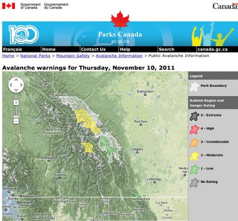
    The good folks at Parks Canada have just launched a new avalanche warning system to help inform you before you head out into the backcountry this season. 

    It takes you to a Google map, where you will see national park boundaries and danger ratings.  From here you can drill down further into the warnings.

    check it out here:http://avalanche.pc.gc.ca
    parks canada avalanche backcountry skiing

    Clicking on any of the regions will take you to a close-up map for that particular region.

    From here, you can select "show weather stations", and wind sock icons will appear. We have made seventeen of our remote weather stations available for viewing. You can see temperature, wind, and snowdepth from the past 24-hours.  It might be a few hours old when you see it, and remember that weather station data can be notoriously suspect from riming or other conditions that effect the sensors.  So take the data with a small grain of salt - if it reads -72, that is probably not correct!  Not all stations have all sensors; some just have wind and temperature, for example.

    The bulletins themselves are now mostly graphical, with a short editorial from our forecasters relating to specific avalanche problems. Much of what you used to get from the text is now represented with graphics.  Learn how to read these and you will get a snapshot of the mountain conditions quickly.

    Bookmark this site on your mobile phone, as you can get all of the same information formatted for Blackberry, iPhone and Android.

    You can also, sign up via Twitter for instant notification of a new bulletin, and the danger rating.

    The Canadian Avalanche Centre will be following suit shortly, and we expect to see a common avalanche bulletin template for all regions within the month.


    Check it out, stay infored and ski safe.