




• Weekly avalanche conditions report
    Weekly Episode

    Avalanche Conditions Report

    Weekly snowpack summary covering Rogers Pass, the Selkirks and the Canadian Rockies. Published every Friday throughout the season.

    Listen Now →

    Weekly avalanche & safety updates throughout the season

  • BSC Guide Books
    Proprietary Content

    BSC Guide Books & Maps

    Researched and written by our team. Printed guides and georeferenced digital maps for Canada's best backcountry terrain.

    Shop the Store →

    Printed guides + georeferenced digital maps — all authored by BSC

  • BSC Membership

    Access 300+
    Full Routes

    Subscribe to Backcountry Skiing Canada and unlock complete route descriptions, trailhead details, approach beta, seasonal conditions and linked digital maps — for every route we've documented across Western Canada.

    • 300+ full route descriptions with trailheads, approach notes and descent options
    • Georeferenced digital maps — Gaia GPS and CalTopo compatible
    • ATES-rated and updated each season with current conditions beta
    • Support independent backcountry skiing content since 2009
    Subscribe to BSC Browse free content →

    Route details also available in BSC printed guidebooks

  • Know Before You Go

    Check Today's Forecast

    Real-time avalanche danger ratings updated daily by Avalanche Canada. Always check before heading out.

    View Forecast →

    Avalanche awareness saves lives

  • Know Before You Go

    Check Today's Forecast

    Real-time avalanche danger ratings updated daily by Avalanche Canada. Always check before heading out.

    View Forecast →

    240+ videos — gear reviews, conditions reports & backcountry edits

LOGIN

Rogers Pass conditions

  • 2011-03-27 10:17:46
    Looks like conditions are holding up well at Rogers Pass, with more snow on the way. Just in time for our yearly trip to the Asulkan Hut - check out the full TR below thanks to the Public Mountain Conditions Report:
    Rogers Pass Backcountry Skiing
    Out for a late morning stroll up to Look Out Col via the Illecillewaet valley today.
    temps remained below zero on the North aspect, with -1.5 at 1500m / 1pm and -3.2 at 2100m / 3 pm observed. a gentle downflow wind kept things cool.
    aprox 5cm of new snow overnight has drifted slightly, leaving pockets up to 10cm deep over top a mix of wind press & temperature crusted snow.  in some spots the new snow had a thin windpress layer on top.  we only saw some very minor cracking around ski tracks (no more than 1m in length) but no signs of instability - the new snow was not reacting in the area we skied.  snow surface remained dry until reaching the valley floor (aprox 1300m), or where there was more sun effect, ie westerly aspects.  we found slightly moist snow on more North West aspects in the area, but none on true North aspects.  no signs of pinwheeling or wet sliding snow on any sun affected slopes we observed.
    trail breaking was easy with a consistent 5-10cm of ski pen, although it was more challenging where the new snow overlies a hard windslab.
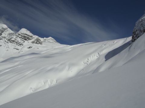
    coverage looked good on the Illecillewaet glacier, with only a few crevasses visible - see picture below taken from just below the Lookout Col.
    happy trails!
    dave healey
    asg