




• Weekly avalanche conditions report
    Weekly Episode

    Avalanche Conditions Report

    Weekly snowpack summary covering Rogers Pass, the Selkirks and the Canadian Rockies. Published every Friday throughout the season.

    Listen Now →

    Weekly avalanche & safety updates throughout the season

  • BSC Guide Books
    Proprietary Content

    BSC Guide Books & Maps

    Researched and written by our team. Printed guides and georeferenced digital maps for Canada's best backcountry terrain.

    Shop the Store →

    Printed guides + georeferenced digital maps — all authored by BSC

  • BSC Membership

    Access 300+
    Full Routes

    Subscribe to Backcountry Skiing Canada and unlock complete route descriptions, trailhead details, approach beta, seasonal conditions and linked digital maps — for every route we've documented across Western Canada.

    • 300+ full route descriptions with trailheads, approach notes and descent options
    • Georeferenced digital maps — Gaia GPS and CalTopo compatible
    • ATES-rated and updated each season with current conditions beta
    • Support independent backcountry skiing content since 2009
    Subscribe to BSC Browse free content →

    Route details also available in BSC printed guidebooks

  • Know Before You Go

    Check Today's Forecast

    Real-time avalanche danger ratings updated daily by Avalanche Canada. Always check before heading out.

    View Forecast →

    Avalanche awareness saves lives

  • Know Before You Go

    Check Today's Forecast

    Real-time avalanche danger ratings updated daily by Avalanche Canada. Always check before heading out.

    View Forecast →

    240+ videos — gear reviews, conditions reports & backcountry edits

LOGIN

Mnt. Whymper Highway 93 south

  • 2011-01-30 00:36:57

    Skied the South ridge of Mnt. Whymper on Sat. of off highway 93 parking at the Marble Canyon parking lot. There was about 20 new sitting on a variety of old snow surfaces sun crusts, facets  and even some old avalanche debris. We managed to get to treeline but didn’t venture any higher. There was a strong cold north wind which was forming soft slabs out of the new snow where it was exposed to the wind but excellent skiing where it’s sheltered.  We skies up and down the ridge and didn’t venture out into the big avalanche paths the affect the highway.  I think the north wind would have been loading lots of snow into there. This is a reverse loading pattern to what is normal here and could really be dumping snow onto weak shallow slopes that are normally wind scoured. 

    here's a Google Earth image of our route
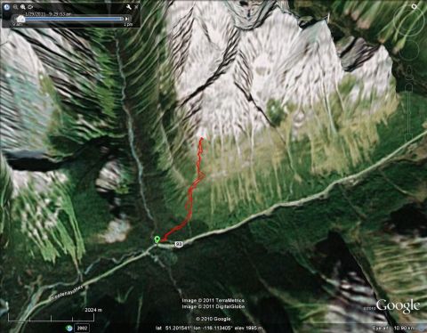
    Mnt Whymper 93 south


  • 2011-01-31 12:52:17

    Hey Joe, whats the vert on this route - any pictures of the terrain? Google map is a good overview, just wondering how it looks on the ground?