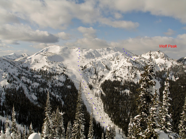



Finally a bluebird day at ol Kootenay Pass! Its amazing what a little vis can do, even after yesterdays long tour, the group was ready to get after it. Maybe it was the sun maybe it was electric energy buzzing overhead in the powerlines. Finally figured it out…the reason the locals call it Buzz's ridge. The goal was to explore the massive bowl at the end of Buzz's ridge, after our tour yesterday we figured it would be more efficient to access the bowl from the Creston side of the pass, rather then dealing with the mile plus of ridge travel across Cornice Ridge Peak. So we made our way up Pristine Pass to just under Wolf peak. From here we traversed under wolf to try and gain the east lip of the massive bowl. Well that turned out to be less than an easy task. After finding a steep but safe route to the bowls east lip, we ended up not able to access the bowl due to what were questionable lines, it was hard to tell if any of the shots underneath our noses would go. Thus we skied the east face from the lip back down towards wolf peak. Still amazing conditions. After this drop we decided to stop for a bit of a food break. This was when the ghost rider broke out of hiding. My unattended board decided to cruz down the mountain without me, first at a crawl, then gathering speed it took a rather aesthetic line down the bowl underneath wolf peak. Derrick and Julie jammed after the runaway while i started postholing to my crotch! After about a 400 foot run, the ghost rider got caught up in two trees at the edge of what would of been a steep shot with no barriers for another 400 or so feet…and surely the end of our day. However it ended up being a slight detour…:) oops! After climbing back out of the bowl, we worked our way south around the edge of the bowl, trying to find another way to access the massive bowl. Unfortunately visibility started to get worse and time was slipping away. Thus we decided for the long shot back down to the power lines, starting from the termination of buzz's and the beginning of the massive bowl. What a line it was, the conditions were great….ooh I can only dream what the north aspect of the massive bowl would of been like. NEXT TIME