

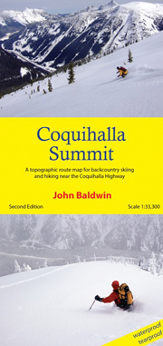
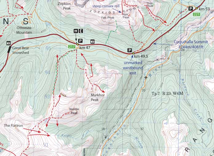
Backcountry Skiing Coquihalla Summit map
Unlock the High-Alpine of the Coquihalla
Discover the deep powder and accessible alpine terrain of Southwestern British Columbia with the Backcountry Skiing Coquihalla Summit Map. This essential navigation tool, created by renowned cartographer John Baldwin, is your ticket to exploring the legendary peaks and bowls surrounding the Coquihalla Highway (Highway 5).
Whether you are planning a quick roadside lap or a full day of touring, this customized topographic map provides the critical details you need for safe and efficient travel. Printed on durable, waterproof, and tearproof paper, it is built to withstand the harsh coastal snowpack and rugged conditions of the Coast Mountains.
|
|
Key Features:
-
Detailed Route Info: clearly marked ski ascents, descent runs, and popular local names.
-
Navigation Ready: 1:50,000 scale based on high-detail TRIM data with 20m contour intervals, 1 km UTM grid lines, and lat/long coordinates.
-
Trip Planning: Includes hiking trails, driving distances, and designated parking areas.
-
Safety Tools: Features a slope angle table relative to contour spacing to aid in avalanche terrain assessment.
From the steep chutes of Zoa Peak to the mellow glades of the Needle, let this map guide your next adventure on the Coquihalla Summit.
The Coquihalla Highway 5 in southwestern British Columbia. Routes are marked on a 1:50,000 scale topographic map and include information on ski ascent routes, ski runs, popular names, hiking trails, driving distances and parking areas.
Features:
- customized topographic map
- detailed ski routes
- backcountry ski runs
- hiking trails
- waterproof, tearproof
- table of slope angle relative to contour spacing
- 1 km UTM grid lines
- latitude and longitude
- based on the detailed TRIM maps
- metric base map with 20m contours
- 27" X 36"
- folds to 4.25" X 9"
- full colour
Coquihalla Summit is a customized topographic map based on the Canadian NTS Topographic maps 92H/10 and 92H/11.
PRICE: $25.00